Why Africa Needs GeoAI Now: The Race to Build Climate-Resilient Intelligence Systems
Africa’s greatest climate challenge isn’t lack of data; it’s lack of intelligence. SpatioNEX is building the next generation of AI-driven geospatial systems to turn Earth observation
Africa is experiencing rapid environmental shifts droughts intensifying across the Horn, unpredictable rainfall patterns crippling farmers, and deforestation altering microclimates faster than policies can adapt. Yet, decision-making across much of the continent still depends on static reports and fragmented data.
We don’t have a data shortage problem; we have a data intelligence gap.
The continent collects terabytes of satellite imagery every day from Sentinel, Landsat, and private constellations but these datasets remain largely underused. What Africa truly needs now is GeoAI: a fusion of geospatial intelligence and artificial intelligence that can analyze, learn, and predict environmental changes in real time.
The Urgent Problem
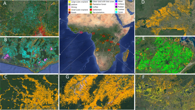
According to the African Development Bank, over 60% of Africa’s cropland remains unmapped at actionable resolution. Governments and organizations still make 80% of resource and climate funding decisions without spatial intelligence. This blind spot costs billions annually through inefficient land use, poor disaster response, and avoidable losses in agriculture and infrastructure.
The result?
Reactive policies, misallocated funds, and delayed response to crises that could have been mitigated or prevented with data-driven insight.
The GeoAI Opportunity
GeoAI transforms how we understand and manage the planet. By training machine learning models on satellite imagery, elevation data, and ground sensors, we can detect deforestation patterns, predict drought risks, and map groundwater potential long before the impact is visible to the human eye.
Imagine:
- Farmers receiving AI-based yield predictions and irrigation guidance directly on their phones.
- County governments monitoring encroachment or flood-prone zones in real time.
- NGOs planning reforestation with data-backed land suitability models.
This isn’t the future - it’s possible now. The tools exist; the challenge is building local intelligence systems that translate this data into contextual, actionable insights for Africa.
SpatioNEX’s Vision
At SpatioNEX Technologies, we are building Africa’s first AI-driven geospatial intelligence platform focused on climate resilience and natural resource management.
Our team combines expertise in GIS, remote sensing, and artificial intelligence to create systems that can:
- Analyze satellite data at scale.
- Automate land cover classification.
- Generate predictive models for drought, flood, and land degradation.
- Deliver spatial insights through APIs, dashboards, and mobile systems.
We envision a future where every environmental decision in Africa is guided by real-time, AI-powered geospatial intelligence from national policy to village-level planning.
This vision isn’t just technological it’s continental. SpatioNEX exists to bridge the gap between data abundance and decision intelligence across Africa.
The Call to Collaborate
We know this mission is bigger than one startup. That’s why we’re inviting researchers, institutions, and innovators to collaborate to co-create datasets, share models, and accelerate Africa’s digital climate transformation.
Our approach is open, transparent, and built for impact. If you’re building in Earth observation, climate tech, or AI for good, join us. The next frontier of climate resilience will be mapped, modelled, and made intelligent together.
Stay at the forefront of geospatial intelligence
Join our community of professionals and receive weekly insights directly in your inbox.
Discussion (0 comments)
No comments yet
Be the first to share your thoughts!