Watershed Sedimentation Intelligence and Forecasting System
Modelling sedimentation in the Upper Athi River Basin using the Revised Morgan–Morgan–Finney (RMMF) model integrated with CA–Markov to quantify rising sediment loads and land-use impacts.
This project applies geospatial modelling and environmental simulation techniques to quantify sediment dynamics and assess the long-term impacts of land-use change on watershed systems.
By integrating hydrological modelling, land-use simulation, and geospatial analytics, the system provides spatial decision support for watershed management, environmental conservation, and sustainable land-use planning.
Key capabilities include:
- Sediment yield modelling
- Watershed analysis
- Land-use change simulation
- Environmental risk assessment
- Spatial forecasting
- Scenario-based planning support
The results support evidence-based interventions aimed at improving watershed resilience and protecting ecosystem services.
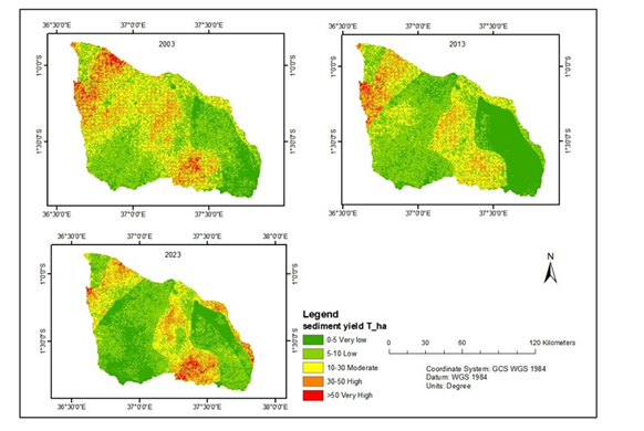
Results
Simulated annual sediment loads:
- 2003: 10.6 million tons
- 2013: 22.6 million tons
- 2023: 36.9 million tons
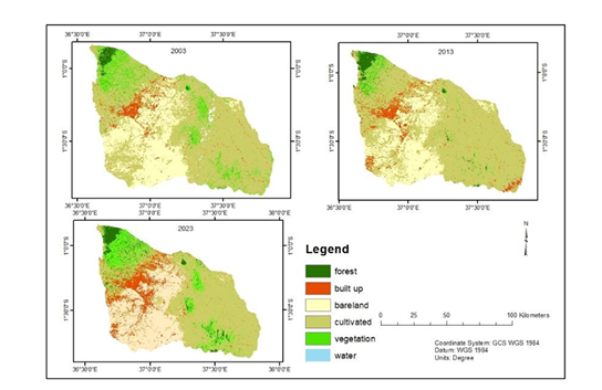
These values indicate a consistent and accelerating increase in sediment yield tied to land-use change and anthropogenic pressures.
Impact & Recommendations
The rising sedimentation threatens water resources, agricultural productivity, and ecosystem stability. Results support targeted soil conservation, land-use planning, and watershed management interventions to reverse trends and meet national development goals.
Ready to Start Your Project?
Let's discuss how we can apply our geospatial intelligence expertise to your environmental monitoring and climate resilience challenges.