
Shaping the Future with Geospatial Intelligence
SpatioNEX harnesses AI-powered satellite and GIS data to deliver actionable insights, helping Africa achieve climate resilience, protect ecosystems, and make informed policy decisions.
African-developed solutions by SpatioNEX
Tailored to local challenges and contexts
90% accuracy
In environmental monitoring (pilot result)
Real-time insights
Updated daily from SpatioNEX satellite data
Trusted by governments
Supporting policy and decision-making across Africa
Our solutions are designed to support policy decisions, climate resilience strategies, and sustainable development efforts.
Discover SpatioNEX Platform
Explore our platform and see how SpatioNEX is transforming climate resilience in Africa through cutting-edge technology and expert solutions.
Latest Insights
Stay updated with our latest research, case studies, and insights on geospatial intelligence and climate resilience.
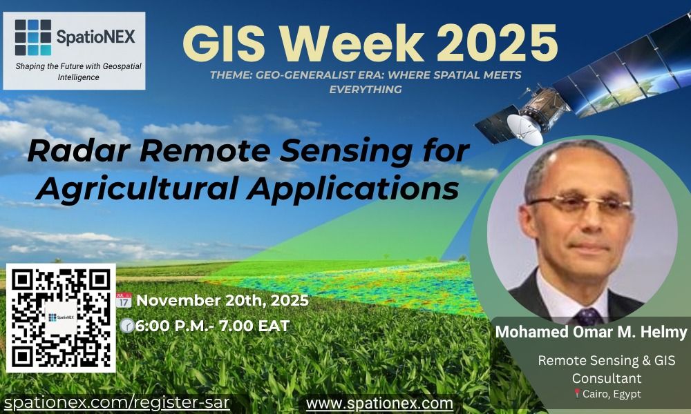
Radar Remote Sensing for Agricultural Applications.
Join SpatioNEX for a power-packed webinar on “Radar Remote Sensing for Agriculture Applications.” Learn how SAR is transforming crop monitoring and climate-smart farming.
Why Africa Needs GeoAI Now: The Race to Build Climate-Resilient Intelligence Systems
Africa’s greatest climate challenge isn’t lack of data; it’s lack of intelligence. SpatioNEX is building the next generation of AI-driven geospatial systems to turn Earth observation
Introducing SpatioNEX: Building Africa’s Next Generation of Geospatial Intelligence
SpatioNEX is redefining how Africa leverages AI, GIS, and remote sensing to tackle climate resilience, natural resource management, and urban development challenges.
Ready to Transform Your Climate Strategy with SpatioNEX?
Join governments and organizations across Africa leveraging SpatioNEX geospatial intelligence to drive data-informed climate resilience.